Resources
Understand the services and availability in your area, as well as the funds and grants which are supporting the expansion of the Regional Broadband Network.
Test the speed of your current internet service and help inform us about Internet speeds in Durham. https://performance.cira.ca/durham
Learn about how Ontario is improving connectivity across the province.
The Government of Canada, Innovation Science and Economic Development (ISED) publishes detailed mapping of broadband availability across the country. This information is based primarily on data collected from Internet Service Providers (ISPs) along with other data sources.
The map is publicly available on the Government of Canada website and can be used to determine the speeds available and the ISPs that offer services in your neighbourhood.
Instructions:
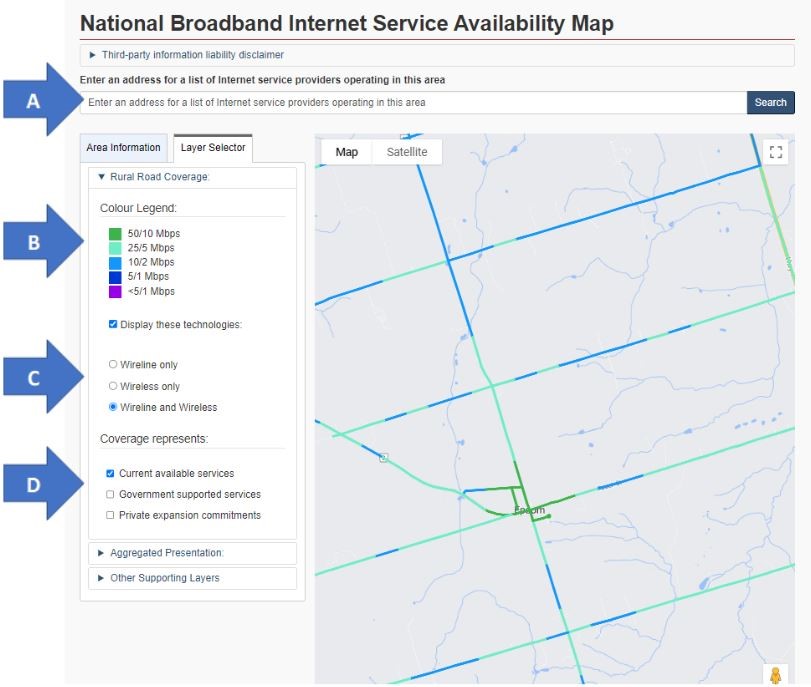
- Select this link to be directed to the National Broadband Internet Service Availability Map.
- Navigate the map by zooming into the area of interest or alternatively enter the street address. Then click “Search”. (Arrow A)
- A street view map will appear showing the general area of your address.
- Zoom and navigate to the specific street you are interested in searching.
- The streets are colour-coded and the legend on the left displays the service levels available. (Arrow B)
- By default, services levels available on both wireline and wireless technologies are shown, however, you could change the display to one or the other types of technologies. (Arrow C)
- Choosing “Wireline only” will display the service levels that are available, over wireline technologies only (in example: Digital Subscriber Line (DSL), coaxial cable, and fibre to the home (FTTH)).
- Choosing “Wireless only” will display the service levels that are available in that area over wireless technologies only (in example: fixed wireless, mobile wireless, satellite).
- Choosing “Wireline and Wireless” will display the service levels that are available in that area over any technology.
- Leave the “Current available services” checked. (Arrow D)
- The other two checkboxes “Government supported services” and “Private expansion services” do not appear to show any more data at this time.
- By selecting a point on the map and then selecting the “Area Information” tab, further details about the service providers and technologies they use to deliver the service can be displayed. Note that these details apply to a larger footprint (grey hexagon on the map) and not to the street view. What this means is that the information may be applicable to some areas within the grey hexagon and not necessarily to all of the grey hexagon. (Arrow E)
Note that this site provides information that is accurate as of the date it was published. Further updates may be added by ISED in upcoming months.
Users are encouraged to contact the listed ISPs directly to determine what services may be available to their specific address.
The following ISP operate in Durham Region. Details about their coverage areas and their service offerings can be found on their websites.
The Centre of Excellence in Next Generation Networks (CENGN) provides best practices and funding for innovative projects across various streams including Residential Broadband and Smart Agriculture.
The Ontario Connects Accelerated High-Speed Internet Program (AHSIP) is run by Infrastructure Ontario and aims to connect every region in Ontario to reliable, high-speed internet by the end of 2025.
Innovation Science and Economic Development (ISED) Canada launched the Universal Broadband Fund (UBF) program in 2021 to improve broadband services in under-served areas.
Durham OneNet, Inc.
3000 Garden Street
Suite #301
Whitby, Ontario
Send an Email